Geospatial - React Native SDK
On this page
New in version 12.0.0.
Geospatial data, or "geodata", specifies points and geometric objects on the Earth's surface. With the geodata types, you can create queries that check whether a given point is contained within a shape. For example, you can find all coffee shops within 15 km of a specified point.
Changed in version realm@12.3.0: Geospatial data supported in Atlas Device Sync
Realm.js v12.3.0 and later adds support for geospatial data in Atlas Device Sync. This allows you to subscribe to geospatial queries in a synced realm. If you try to subscribe to a geospatial query with an older version of the SDK, you will receive a server error with a compensating write. For more information about managing your Sync subscriptions, refer to Geospatial - React Native SDK.
For more information on querying geospatial data with Device Sync, refer to Geospatial Data in the App Services documentation.
Geospatial Data Types
The SDK supports geospatial queries using the following data types:
GeoPoint
GeoCircle
GeoBox
GeoPolygon
The SDK provides these geospatial data types to simplify querying geospatial data. You cannot persist these data types directly.
For information on how to persist geospatial data, refer to the Persist Geospatial Data section on this page.
To query against geospatial data, you can use the geoWithin operator
with RQL. The geoWithin operator takes the coordinates
property of an embedded object that defines the point we're querying, and
one of the geospatial shapes to check if that point is contained within
the shape.
Note
The format for querying geospatial data is the same, regardless of the shape of the geodata region.
GeoPoint
A GeoPoint defines a specific
location on the Earth's surface. All of the geospatial data types use GeoPoints
to define their location.
GeoPoint can be one of three types:
An object with:
latitude: a number valuelongitude: a number valuealtitude: an optional number value
CanonicalGeoPoint: an interface that satisfies the GeoJSON specifications for a pointGeoPosition: an array with longitude, latitude, and an optional altitude
A GeoPoint is used only as a building block of the other shapes: GeoCircle, GeoBox, and GeoPolygon. These shapes, and the GeoPoint type, are used in queries, not for persistance.
To save geospatial data to realm, refer to Persist Geospatial Data on this page.
GeoCircle
A GeoCircle defines a circle on
the Earth's surface. You define a GeoCircle by providing:
A
GeoPointfor the center of the circleA number for the distance (radius) of the circle
The radius distance uses radians as the unit of measure. The SDK
provides the methods kmToRadians and miToRadians to convert
kilometers or miles to radians.
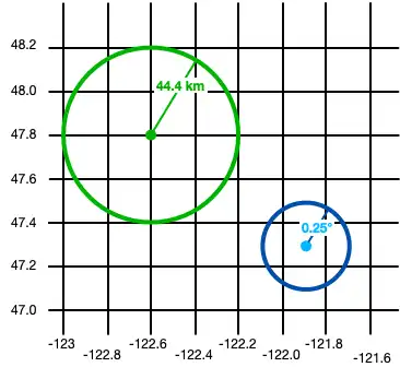
The following code shows two examples of creating a circle:
import React from 'react'; import {View, Text} from 'react-native'; import {GeoCircle, GeoPoint, kmToRadians} from 'realm'; import {useQuery} from '@realm/react'; function Geocircle(): JSX.Element { // Define a GeoCircle const smallCircle: GeoCircle = { center: [-121.9, 47.3], // The GeoCircle radius is measured in radians. // This radian distance corresponds with 0.25 degrees. distance: 0.004363323, }; // Realm provides `kmToRadians` and `miToRadians` // to convert these measurements. Import the relevant // convenience method for your app's needs. const radiusFromKm = kmToRadians(44.4); // Define a GeoPoint within a GeoCircle const largeCircleCenter: GeoPoint = { longitude: -122.6, latitude: 47.8, }; const largeCircle: GeoCircle = { center: largeCircleCenter, distance: radiusFromKm, }; // Query geospatial data const companiesInSmallCircle = useQuery( Company, collection => collection.filtered('location geoWithin $0', smallCircle), [smallCircle], ); // Query geospatial data const companiesInLargeCircle = useQuery( Company, collection => collection.filtered('location geoWithin $0', largeCircle), [largeCircle], ); return ( <View> <Text>Small circle: {companiesInSmallCircle.length}</Text> <Text>Large circle: {companiesInLargeCircle.length}</Text> </View> ); }
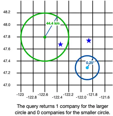
The following image shows the results of creating two objects: a small circle and a large circle.

Queries against geospatial data return realm objects within the shapes you define. From the example above, this is the result of our queries:

GeoBox
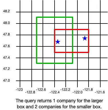
A GeoBox defines a rectangle on the Earth's surface. You define the rectangle by specifying the bottom left (southwest) corner and the top right (northeast) corner. A GeoBox behaves in the same way as the corresponding GeoPolygon.
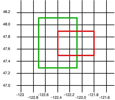
The following example creates 2 boxes:
import React from 'react'; import {View, Text} from 'react-native'; import {GeoBox, GeoPoint} from 'realm'; import {useQuery} from '@realm/react'; function Geobox(): JSX.Element { // Define a GeoBox const largeBox: GeoBox = { bottomLeft: [-122.7, 47.3], topRight: [-122.1, 48.1], }; // Define GeoBox corners const smallBoxBottomLeft: GeoPoint = { longitude: -122.4, latitude: 47.5, }; const smallBoxTopRight: GeoPoint = { longitude: -121.8, latitude: 47.9, }; const smallBox: GeoBox = { bottomLeft: smallBoxBottomLeft, topRight: smallBoxTopRight, }; // Query geospatial data const companiesInLargeBox = useQuery( Company, collection => collection.filtered('location geoWithin $0', largeBox), [largeBox], ); // Query geospatial data const companiesInSmallBox = useQuery( Company, collection => collection.filtered('location geoWithin $0', smallBox), [smallBox], ); return ( <View> <Text>Small box: {companiesInSmallBox.length}</Text> <Text>Large box: {companiesInLargeBox.length}</Text> </View> ); }
The following image shows the results of creating two objects: a small box and a large box.

Queries against geospatial data return realm objects within the shapes you define. From the example above, this is the result of our queries:

GeoPolygon
A GeoPolygon defines a polygon on the Earth's surface. Because a polygon is a closed shape, you must provide a minimum of 4 points: 3 points to define the polygon's shape, and a fourth to close the shape.
Important
The fourth point in a polygon must be the same as the first point.
You can also exclude areas within a polygon by defining one or more "holes". A hole is another polygon whose bounds fit completely within the outer polygon. The following example creates 3 polygons: one is a basic polygon with 5 points, one is the same polygon with a single hole, and the third is the same polygon with two holes:
import React from 'react'; import {View, Text} from 'react-native'; import {GeoPolygon, GeoPoint} from 'realm'; import {useQuery} from '@realm/react'; function Geopolygon(): JSX.Element { // Define a basic GeoPolygon const basicPolygon: GeoPolygon = { outerRing: [ [-122.8, 48.0], [-121.8, 48.2], [-121.6, 47.6], [-122.0, 47.0], [-122.6, 47.2], [-122.8, 48.0], ], }; // Define a GeoPolygon with one hole const outerRing: GeoPoint[] = [ [-122.8, 48.0], [-121.8, 48.2], [-121.6, 47.6], [-122.0, 47.0], [-122.6, 47.2], [-122.8, 48.0], ]; const hole: GeoPoint[] = [ [-122.6, 47.8], [-122.2, 47.7], [-122.6, 47.4], [-122.5, 47.6], [-122.6, 47.8], ]; const polygonWithOneHole: GeoPolygon = { outerRing: outerRing, holes: [hole], }; // Add a second hole to the GeoPolygon const hole2: GeoPoint[] = [ { longitude: -122.05, latitude: 47.55, }, { longitude: -121.9, latitude: 47.55, }, { longitude: -122.1, latitude: 47.3, }, { longitude: -122.05, latitude: 47.55, }, ]; const polygonWithTwoHoles: GeoPolygon = { outerRing: outerRing, holes: [hole, hole2], }; // Query geospatial data const companiesInBasicPolygon = useQuery( Company, collection => collection.filtered('location geoWithin $0', basicPolygon), [basicPolygon], ); // Query geospatial data const companiesInPolygonWithTwoHoles = useQuery( Company, collection => collection.filtered('location geoWithin $0', polygonWithTwoHoles), [polygonWithTwoHoles], ); return ( <View> <Text>Basic polygon: {companiesInBasicPolygon.length}</Text> <Text> Polygon with two holes: {companiesInPolygonWithTwoHoles.length} </Text> </View> ); }
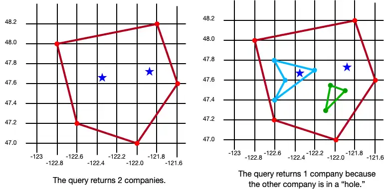
The following image shows the results of creating three objects: a polygon, a polygon with one hole, and a polygon with two holes.

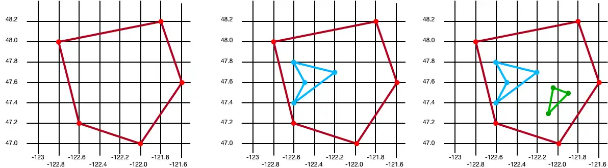
Queries against geospatial data return realm objects within the shapes you define. From the example above, this is the result of our queries:

Persist Geospatial Data
Important
Cannot Persist Geospatial Data Types
Currently, you can only persist geospatial data. Geospatial data types cannot be persisted directly. For example, you
can't declare a property that is of type GeoBox.
These types can only be used as arguments for geospatial queries.
If you want to persist geospatial data, it must conform to the GeoJSON spec.
Create a GeoJSON-Compatible Class
To create a class that conforms to the GeoJSON spec, you:
Create an embedded realm object. For more information about embedded objects, refer to Embedded Objects - React Native SDK.
At a minimum, add the two fields required by the GeoJSON spec:
A field of type
double[]that maps to a "coordinates" (case sensitive) property in the realm schema.A field of type
stringthat maps to a "type" property. The value of this field must be "Point".
To simplify geodata persistance, you can define a model that implements
CanonicalGeoPoint, which already has the correct shape. The following
example shows an embedded class named MyGeoPoint that is used
to persist geospatial data.
You then use the custom MyGeoPoint class in your realm model, as shown in the
following example. You add instances of your class to the realm just like any other Realm
model. However, in this example, because the MyGeoPoint class does not
extend Realm.Object, we must specify MyGeoPoint.schema when opening
the realm:
import React from 'react'; import Realm, {ObjectSchema, CanonicalGeoPoint, GeoPosition} from 'realm'; import {RealmProvider} from '@realm/react'; // Implement `CanonicalGeoPoint` // for convenience when persisting geodata. class MyGeoPoint implements CanonicalGeoPoint { coordinates!: GeoPosition; type = 'Point' as const; constructor(long: number, lat: number) { this.coordinates = [long, lat]; } static schema: ObjectSchema = { name: 'MyGeoPoint', embedded: true, properties: { type: 'string', coordinates: 'double[]', }, }; } class Company extends Realm.Object<Company> { _id!: number; location!: MyGeoPoint; static schema: ObjectSchema = { name: 'Company', properties: { _id: 'int', location: 'MyGeoPoint', }, primaryKey: '_id', }; } export const Geospatial = () => { return ( <View> {/* `MyGeoPoint` does not extend `Realm.Object`, so you pass only the `.schema` when opening the realm. */} <RealmProvider schema={[Company, MyGeoPoint.schema]}> <WriteGeospatialObjects /> </RealmProvider> </View> ); };
Write the Embedded Class
Within RealmProvider, create your geospatial objects by combining the
embedded class with classes that extend Realm.Object.
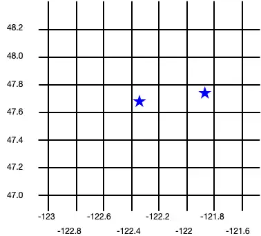
import React from 'react'; import {View} from 'react-native'; import {useEffect} from 'react'; import {useRealm, useQuery} from '@realm/react'; function WriteGeospatialObjects(): JSX.Element { const realm = useRealm(); const companies = useQuery(Company); useEffect(() => { if (!companies.length) { // Add geospatial objects to realm. writeNewCompany({_id: 6, location: new MyGeoPoint(-122.35, 47.68)}); writeNewCompany({_id: 9, location: new MyGeoPoint(-121.85, 47.9)}); } }, []); type CompanyProps = { _id: number; location: MyGeoPoint; }; const writeNewCompany = ({_id, location}: CompanyProps) => { // Add geospatial object to realm. realm.write(() => { realm.create(Company, { _id, location, }); }); }; return ( <View> <Geocircle /> <Geobox /> <Geopolygon /> </View> ); }
The following image shows the results of creating these two company objects.